

From Svalbard to Scotland: A 3,100 km Expedition Through One of Earth’s Last Untamed Frontiers
We’re on our way!
We’re on our way!
Once we’ve set off you can track our progress on the map above. We’ll also be posting sharing photos, videos and text notes throughout our expedition.
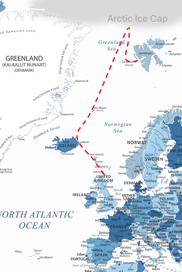
We’re starting in Longyearbyen, Svalbard, one of the northernmost towns in the world. From here, we head north to meet the edge of the polar ice. The ice shifts from year to year, and its position ultimately decides how far north we can go. Reaching it marks the true beginning of our Arctic journey.
Once we turn south, we follow the East Greenland Current — a major surface flow of cold water that runs down the eastern side of Greenland. This section combines long stretches of open water with areas where drift ice can appear quickly, shaped by wind and weather. It’s remote, quiet, and humbling in its scale.
Roughly halfway along the route lies Jan Mayen, a volcanic island that sits alone between Greenland and Iceland. Depending on conditions, we will either pass near Jan Mayen or aim for the channel between the island and Greenland. The decision will be made on the water, based on currents, safety, and daily progress.
The final phase takes us from Iceland toward the Faroe Islands and then into northern Scotland, where we plan to make landfall. This section has been crossed before by small craft and is considered navigable, though still demanding in typical North Atlantic weather.
In total, the route covers around 3,100 km. Conditions will vary, but we expect to be at sea for 40 to 60 days. Like every journey in the Arctic, the route is shaped as much by nature as by planning — and that is exactly why we’re drawn to it.
~3,100 km total distance covered
40–60 days anticipated time at sea (weather dependent)
Northernmost point: The polar ice edge north of Svalbard
120 km daily distance rowed
3m total strokes rowed